DIGITAL TRANSFORMATION IN CONSTRUCTION
The rapid technological development in the production of materials, equipment and offered services necessitates the search for solutions to increase efficiency, quality and competitiveness in all sectors of production and the economy through the development and implementation of numerous information solutions. Digital transformation is key to the development of the construction sector, and for this reason the “European Digital Innovation Hub in the Construction Sector” Association has set itself the main task of creating a high-tech centre, which integrates expert potential, networks of partnerships and resources for the provision of training and services, aimed at business and the public sector, to support the implementation of this process.
As part of the implementation of the “Enabling the digitalization in construction” project, financed under the “Digital Europe” Program of the EC, the “EDIH in Construction” Association will offer a wide range of specialized training and services in various areas to satisfy the need for digital technologies in the entire construction-investment process, including BIM (Building Information Modelling) and GIS (Geographic Information System). They will be aimed mainly at specialized architects and engineers and will aim to increase their qualifications and competitiveness in the sector.
Access to training and testing of various BIM and GIS products will provide businesses with opportunities for more in-depth research and identification of the needs for implementing similar technologies, increasing the quality of the services they offer and meeting the requirements of ever-increasing demand in this field for both specialists and for new projects. The technology will optimize the design, construction and management, and other processes of the buildings, reduce the costs per unit of construction output, reduce the carbon footprint and meet the European requirements.
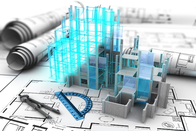
BIM (Building Information Modeling)
What is BIM?
BIM is a comprehensive process of creating and managing information of a given construction site (asset). Based on an intelligent model, stored on a cloud platform, BIM integrates structured, multidisciplinary data to create a digital representation of the given asset throughout its life cycle, from planning and design, to construction, and to its management and maintenance. Work processes in BIM start from research and proceed into design, creation of digital databases of the characteristics of different construction products, creating 3D models of buildings, construction, management of operating costs of constructions, their repairs, renovations and finally to their demolition.
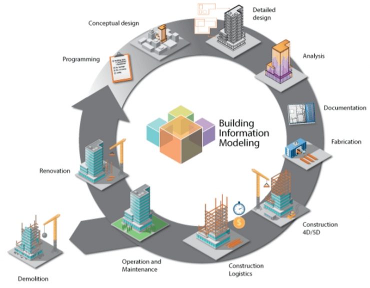
Each of the work processes has its own different specification, implementation team, processes, planning and teams, all of which are interconnected and interdependent with the aim of proceeding through the individual stages not just until the project’s completion, but for the overall management of the completed building or infrastructure to the end of its life cycle. The four main stages of the BIM process can be defined as follows:
Planning
It is based on a combination of data obtained through geodetic methods, 3D scanning of surfaces and objects, available area plans and data from other available sources to generate complex models of the existing and natural environment.
Design
During this stage, the conceptual design, analyses, evaluations, the complete project documentation of the site in all parts (architecture, construction, plumbing, electrical, HVAC, and other types of
installations, landscaping, roads, geodesy, etc.) are developed into a common model. The collected data from the “Planning” stage is used in the preparation of the project, the work schedules and organization plans, the logistics details, etc. are also created. Arrangements are made with the relevant authorities, who are given an appropriate level of access to the project documentation and other necessary information;
Construction
This is the construction phase of the site according to the information (models, work schedules, documentation) prepared in the first two stages of BIM. Access to the data of builders, suppliers, control bodies, etc. related to the construction of the site is provided. During the entire construction stage, the created dynamic model, which responds to changing individual parameters, materials, and other type of changes, is used.
Management and support
In this phase, BIM data is supplemented and used for management, monitoring and maintenance of the assets of the given site, tracking the condition and operating parameters of the types of installations in real time, which is a prerequisite for early diagnosis of pre-emergency and emergency situations. Built-in sensors and devices for reading and controlling heating and ventilation, fire detection, video surveillance, counting parked cars, irrigation systems, water consumption, energy consumption or production, appliance management, IoT, etc. allows the so-called “smart buildings” to be managed as efficiently as possible and their costs, periods of renovation and repair activities, etc. to be planned optimally.
Advantages of BIM
The numerous advantages to utilizing BIM in the entire construction-investment process are related to the optimization of processes, shortening of execution terms, minimizing the risks of duplication of activities and errors, reduction of construction and building management costs, as well as increasing the efficiency and quality of the implemented projects. In the BIM environment, a complete virtual model of the building or facility to be built is created. All information and documentation of the project is managed through it. This is achieved by connecting teams, workflows and data throughout the lifecycle – from survey to overall site management.
GIS (GEOGRAPHIC INFORMATION SYSTEM)
What is GIS?
Geographic Information Systems (GIS) are computer systems of specialized hardware and software that analyse and display geographically related information. They use data that is attached to a unique location or all data is georeferenced.
The essence of geographic information systems consists in the collection of maps, the creation of a database and the modelling of complex information with the indication of the interrelationships between individual elements.
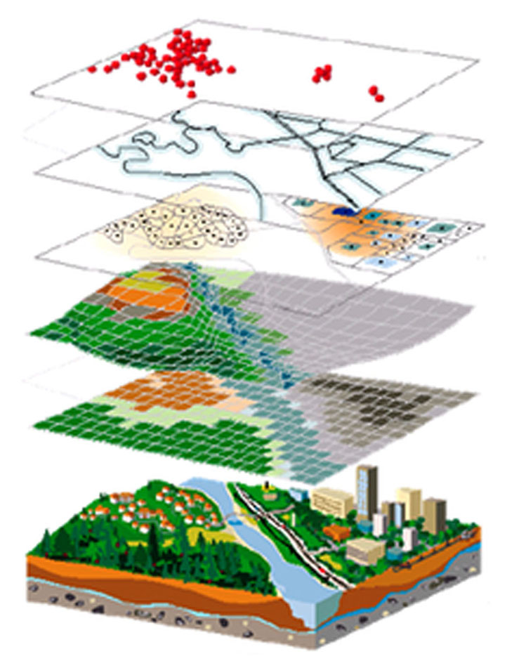
GIS provide information about objects, strictly defined in spatial terms, using various geodetic methods in a defined coordinate system and a database, which characterizes these objects – integrating spatial and non-spatial data and modelling of the environment. GIS provide a comprehensive process created through specialized computer software for creation, processing, visualization, analysis and storage of
information related to the spatial location of a certain object. Data visualization can be done selectively in certain layers and thus combine different types of information needed to solve specific tasks, e.g. the combination of information from different types of plans for a part of a settlement – cadastral map, map of underground communications, layout plans with property information, data on issued building permits or orders of competent institutions, burdens imposed on objects, defined regimes for the territory, etc.
Advantages of GIS
Much of the information that is used in everyday life is location-referenced and one of the products of GIS is the various thematic maps in many areas of life, e.g. climate maps with visualization of changes in different time periods and opportunities for predictive analyses; maps of floods for a certain territory; maps of fire hydrants in a given region; traffic maps at certain intersections, etc. Another application of GIS can also be found in resource management, regional and territorial planning, ecology, telecommunications, etc. Through GIS, it is possible to make analyses, forecasts and risk assessments in certain areas, to visualize changes during certain periods, to carry out assessments according to set criteria, to determine quantitative or qualitative indicators depending on the created database.